Posts

Showing posts from July, 2013

RV7 Flight: Joseph, Oregon in July

Image
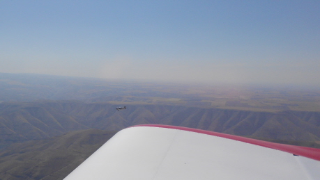
The last time hubby and I took an afternoon flight to Joseph, Oregon was a little over a year ago. You can read my first Joseph post here. It was March 2012, and decidedly not yet tourist season for the tourist town. Yesterday, some friends accompanied us: Vince and Sharon Himsl. Sharon might be posting pictures on her blog , so if you're interested, check hers out in the next day or two. If you look closely off of the left side of our wingtip, you can see their airplane. Vince built a Vans RV-8, which is similar to our Vans RV-7, except that theirs is tandem seating (like a motorcycle), whereas ours is side-by-side. Here we are, just coming into the Enterprise/Joseph area, which abuts the Willowa mountain range. The mountains rise about 6,000 feet above a plateau that is already at a 4,000' elevation. We left in the heat of the afternoon, and so the air was very choppy with thermals. Sharon, her husband Vince, and my husband, Mike. As it happened, Joseph had a huge rodeo on S

RV7 Flight: Saskatchewan, Part 3

Image
When the weather was good enough to fly home on Tuesday, though it was cloudless in Montana, it was still only marginal in Canada. It was so hazy that visibility was limited, but enough, as long as the clouds didn't turn to fog and sock us in. That would've been big trouble. We flew only about 800 feet above ground level, which is a couple thousand feet lower than the altitude at which we normally fly.  It was also mildly turbulent, however as we crossed over into Montana, and the low clouds gave way to higher, cumulus clouds, the turbulence increased ten-fold. Or it felt like that much. I used to get sick regularly in our Maule, due to a variety of reasons, however I have never been sick in the RV-7 ... until Tuesday.  The big problem was that we couldn't land at just any nearby airport, assuming there were airports below us somewhere. We needed to go through U.S. Customs, and that can only happen at certain airports. We had to get back to Great Falls for that. And so ...

RV7 Flight: Saskatchewan, Part 2

Image
So there we were, flying over a desolate area of Montana toward the Canadian border. We were without the ability to make radio contact with anyone, although we were on radar. When you get on radar, your transponder "squawks" a code that identifies which plane you are in the vast atmosphere.  Though on radar, we were very swiftly approaching the border, which hubby decided we should not cross unless we were in radio communication with Winnipeg Center.  This little blip (no radio contact) came as a big surprise to him, as well as that Salt Lake Center had no record of him filing an International Flight Plan. He had done so much research about flying into Canada. We both got passports, a requirement. He made a huge "N" number (airplane identifying number) on the side of the airplane with electrical tape, above.  In America, N numbers need be only 3" tall. For border crossings, they need to be 10". After landing in Great Falls, we checked to make sure the elec

RV7 Flight: Saskatchewan, Part 1

Image
We left at 8:30 am. PST on July 4 and got home at 6:30 pm PST on July 9. To drive there, it would've taken 20 hours. To fly in our RV-7, had we not stopped for fuel, and if everything had gone as planned, it would've taken 4.5 hours. As it turned out, it took 11 hours to get there, after a considerable amount of trials and tribulations, of which I will write about!  This was our first long cross country, International flight, and so the learning curve for hubby was very steep indeed, however it was also very good for him.  The first picture, above, is our "luggage compartment." The RV-7 can hold 100 pounds of luggage in addition to hubby's and my weight. If I were 30 pounds lighter, as I should be, we could carry 30 pounds more. It's all about weight and balance.  We always park our car in the hangar whenever we leave. Second picture shows exactly that.  This third picture is of the instrument panel. Hubby has some pretty fancy electronic navigational   tools,