RV7 Flight around Mt. St. Helens
A couple weeks ago, we flew around Mt. St. Helens with some friends. We flew our RV-7 and they flew their RV-8. Mt. St. Helens erupted on May 18, 1980. Since then the mountain’s been rebuilding itself at an astonishing rate. When we visited it a few years ago, experts at the interpretive center gave us an estimate. By my husband’s quick mental calculations, the huge crater might have completely rebuilt itself by the time we’re 80 years old. Geologically speaking, that’s the lifespan of a gnat. We’re hoping to be spry enough to fly around it again when we’re eighty. Here are some pictures:
 Mt. St. Helens is fairly close to Mt. Rainier, which we passed first.
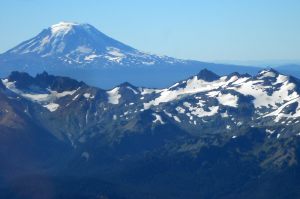
 Beyond Mt. Rainier is Mt. Adams, then Mt. St. Helens, and then Mt. Hood in the far distance. (Mt. St. Helens isn’t seen in this picture.)
 Here is my first picture of the dry old volcano. We are heading southwest and will make a clockwise loop around it.
 Trees from the devastation 34 years ago still fill Spirit Lake. When I was a teenager, we used to camp at Mt. St. Helens. Spirit Lake was fun to swim in.
 Here, we’re coming upon the crater, and the dome that is rebuilding itself, from the southeast.
 Here we’ve turned the corner and are looking back at Spirit Lake and Mt. Rainier in the distance.
 This is the dome from the west side, Mt. Adams in the distance.


Here’s another view of the dome. The air was quite unsettled that day. Lots of bouncing up and down.
One last view of the dome and we’re on our way to land at Packwood, a little town nestled at the foot of Mt. Rainier.
Here’s the image our AvMap showed of our neat little circle around the crater. You can see the path we took, which looks like a pencil drawing around the mountain, with a little airplane drawn in. The stuff that’s green is the terrain we flew over, which was safely below the altitude at which we were flying–9500 feet. The stuff that’s yellow would be marginal. The dot that’s red is higher than we were. Wouldn’t want to venture into the red zone.
Here’s a picture of Mt. Rainier rising above Packwood and the valley below, which is at 1000 feet. We needed to quickly dump 8500 feet in elevation, make a sharp, 180 degree turn, and land on the long but narrow runway at Packwood. Oh, and we needed to clear the trees at the end of the runway. All amidst considerable turbulence.
We walked around town and ate a yummy lunch at one of the two or three restaurants. We checked out the quaint library and the old log cabin-like hotel. I couldn’t believe how hot it was–close to 90 degrees.
Here we’re getting ready to fly home. Since Vince hasn’t had a lot of experience with mountain flying, Mike and I took off first to check out the conditions. A heavy crosswind blew down the runway, which complicates takeoffs. Taking off to the North, we also needed to gain a heck of a lot of altitude–8600 feet–before being above most high-rising peaks. The takeoff was like a bucking bronc. The air smoothed out a little once we reached altitude, although we experienced moderate choppiness all the way home.
Vince caught a picture of our fuselage belly at takeoff. Cool image!


Comments
Post a Comment
Hey, thanks for commenting!