RV7 Flight to Arizona: Part 1
Last Monday, we were slated to go to Arizona. We didn’t know if we could fly, or be forced to drive, but we hoped to fly. The weather reports had all been forecasting great weather for Monday, and when we got up that morning, the forecasts were correct. So instead of driving for three days, we hopped in the plane and began the 5.5 hour flight.
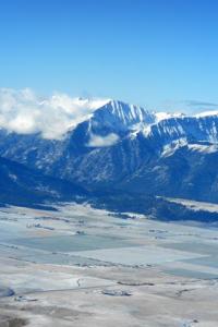 The snow-capped Willowas looked lovely. Joseph and Enterprise, Oregon, at the foothills of the mountains, had a dusting of frost.
 The weather was a bit unsettled, and we flew by lots of puffy cumulus clouds.
 Here we’re crossing the Snake River and Hell’s Canyon. If you look closely, you can see a dam across the river.
 About an hour after takeoff, we made our first stop in Nampa, Idaho, which is just a few miles outside of Boise.
 With three scheduled stops before arriving in Wickenburg, Arizona, and with foreshortened daylight, we needed to make fast turnarounds or we wouldn’t get to Wickenburg before the sun set. In Nampa, between refueling, opening a new flight plan, and taking a potty break, we did it all in 40 minutes. That was a bit too long. After Nampa, we shaved off a few more minutes by paying a few cents more per gallon of fuel and having the FBO refill it instead of doing it ourselves. That left us free to complete the other necessities, and we saved 10 minutes at each stop.


Comments
Post a Comment
Hey, thanks for commenting!